


Montours-La Villette-Courtine 18km JY

COGLAIS3
User
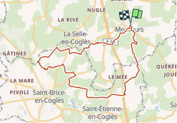

Length
18.1 km

Max alt
164 m

Uphill gradient
200 m
Km-Effort
21 km

Min alt
102 m

Downhill gradient
210 m
Boucle
Yes
Creation date :
2023-05-02 06:10:37.508
Updated on :
2024-11-01 17:51:06.65
3h50
Difficulty : Very easy

FREE GPS app for hiking
 SityTrail
IGN / Geographical institutes
SityTrail Plus
The world is yours!
About
Trail Nordic walking of 18.1 km to be discovered at Brittany, Ille-et-Vilaine, Les Portes du Coglais. This trail is proposed by COGLAIS3.
Positioning
Country:
France
Region :
Brittany
Department/Province :
Ille-et-Vilaine
Municipality :
Les Portes du Coglais
Location:
Unknown
Start:(Dec)
Start:(UTM)
625155 ; 5367011 (30U) N.
Comments